I have posted this trip as a Level 3 trip because we will do the trip if Level 3 conditions prevail, those being
"Paddling is in bays or lakes with slightly choppy to choppy conditions with waves up to 2 feet and currents up to 2 knots.
You should be able to paddle in up to 2 foot chop in 15 knot winds. You must be able to perform a wet exit, and you should be able to perform both a self-rescue and partner rescue in level 3 conditions. You should have good basic strokes especially good bracing skills. "
.
15 knot southish winds will be ok. 12+ knot northish winds might cancel the trip. The day may be much milder than the above but you should be prepared to do the trip in Level 3 conditions.
Spray skirts will be required. Dress for possible immersion in 70 degree water. You should have a paddle float and pump. Bring a radio and tow belt if you have one. We will be paddling across San Luis Pass going and coming landward of the bridge where tidal current on this day should not be strong, but there will be some.
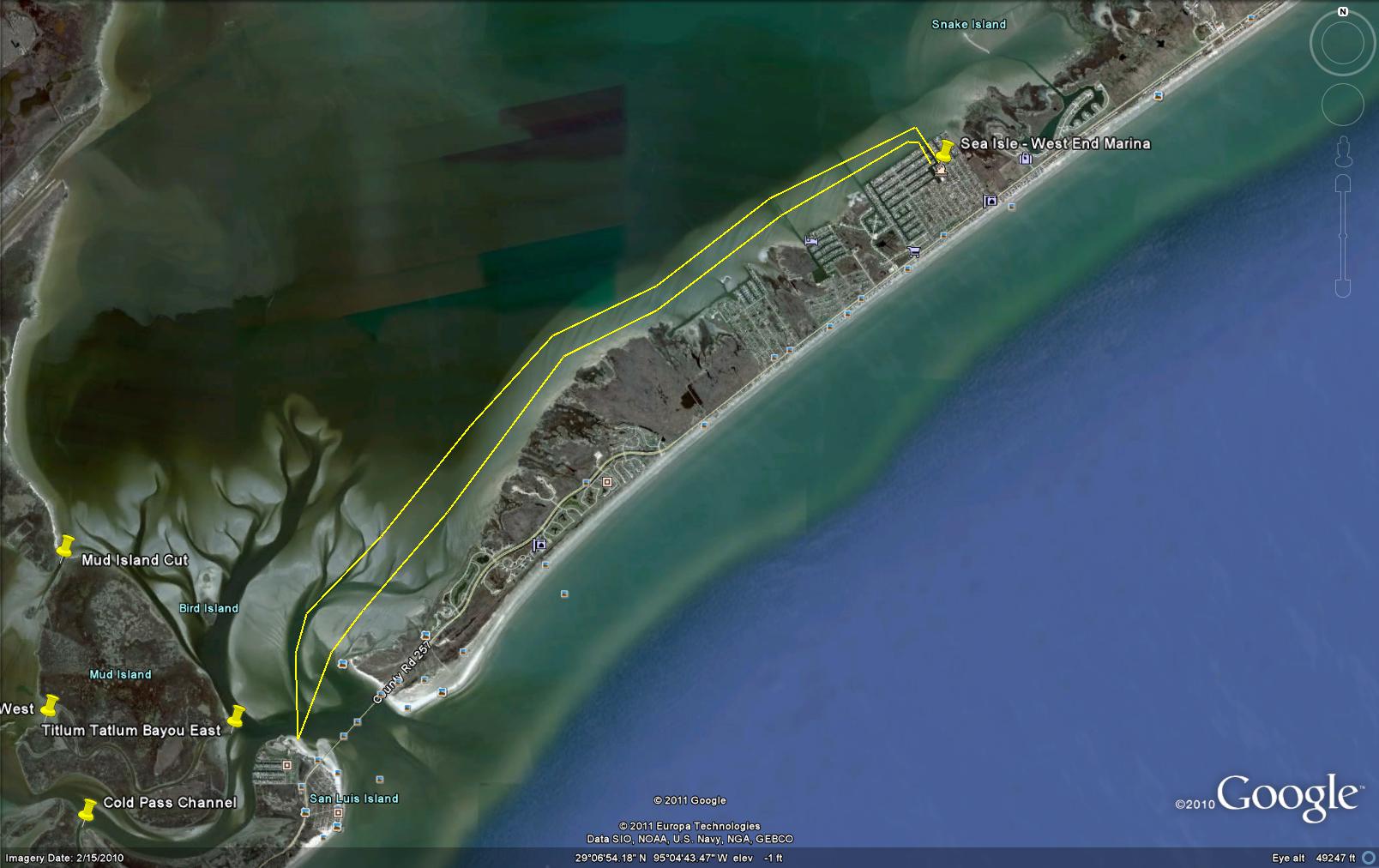
Trip Description: Get your booties out and help us paddle Galveston's backside. Our crack HASK team will do a "pun"ishing fifteen mile Level 3 paddle along the southern shore of Galveston Bay and then R&R at a local restaurant for dinner.
We'll put in at the West End Marina in Sea Isle and paddle to San Luis Pass for lunch, then paddle back to the put-in. Round trip is about 15 miles. We'll find a place to bend over and stretch on each leg of the trip.
We'll aim to finish up around dinner time and eat at one of Galveston's fine establishments.
Driving directions: From 61st Street and the Seawall in Galveston, drive SW on Seawall Blvd (FM 3005) 15.7 miles to San Jacinto Drive. From San Luis Pass, drive 6.5 miles northeast on FM 3005 ro San Jacinto Drive.
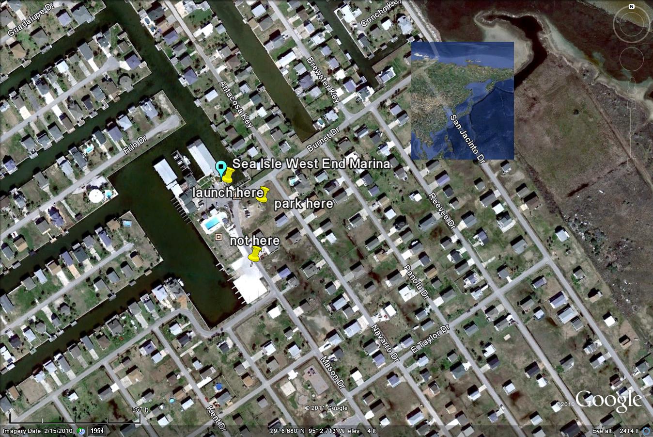
From that intersection, drive 0.4 miles north on San Jacinto Drive, then 0.2 miles west on Burnet Drive. The West End Marina will be right in front of you. A vacant lot will be immediately on your left. Park there, take down your boat, and load it for the trip. We will then carry boats across the street to the boat ramp and quickly put in together to avoid congesting the harbor. Or we may be able to unload in front of the marina and move our cars to the vacant lot across the street. There is no launch fee. Also don't go to the private subdivision club and ramp around the corner on Mason Drive. Let's meet at about 9:30 to launch at 10:00 a.m.
Here's what the launch area looks like from 2500 feet above, in case you're arriving from that direction:
Hazards: Hazards will include heat, dehydration, chafing, oysters, piles, pilings, immersion in cool water, some boat traffic, jellyfish, indigestion, seasickness, stingrays, fire ants, snakes, mosquitos, fishhooks, thunderstorms, bad jokes, and any imaginable freak occurrence. We will try to avoid hazards but remember, it's your "asterisk". Most importantly, bring plenty of water and sun protection and snacks in case this runs long.
| Trip Leader |
Carl Kuhnen
|
| Trip Assistants |
Bruce Asher, Don Friedly |
| Trip Rating* |
3 |
| Ready to Launch at |
10:00 a.m.
|
| Duration (hours) |
7 |
| Paddling Miles |
15
|
| Emergency Initiator |
|
| Emergency Phone #s |
Galveston Coast Guard 409-766-5633
Galveston Sheriff 409-766-2322
281-534-3515
|
| Latest Expected Return |
6 p.m.
|
| Auto Description/Lic # |
|
| Distance from Houston |
67 miles from downtown
|