Oyster Lake / Palacios Point Loop
June 27 2021
This is a 11.5-mile circle route described on pp 59 – 60 of Kayaking The Texas Coast, by John Whorff. It takes in Oyster Lake and Matagorda Bay, and a little bit of the Intra Coastal Waterway (ICWW). According to Whorff, attractions include beautifully vegetated bluffs, beautiful shell beaches, ruins from the Old Days, good bird watching and possible dolphins.
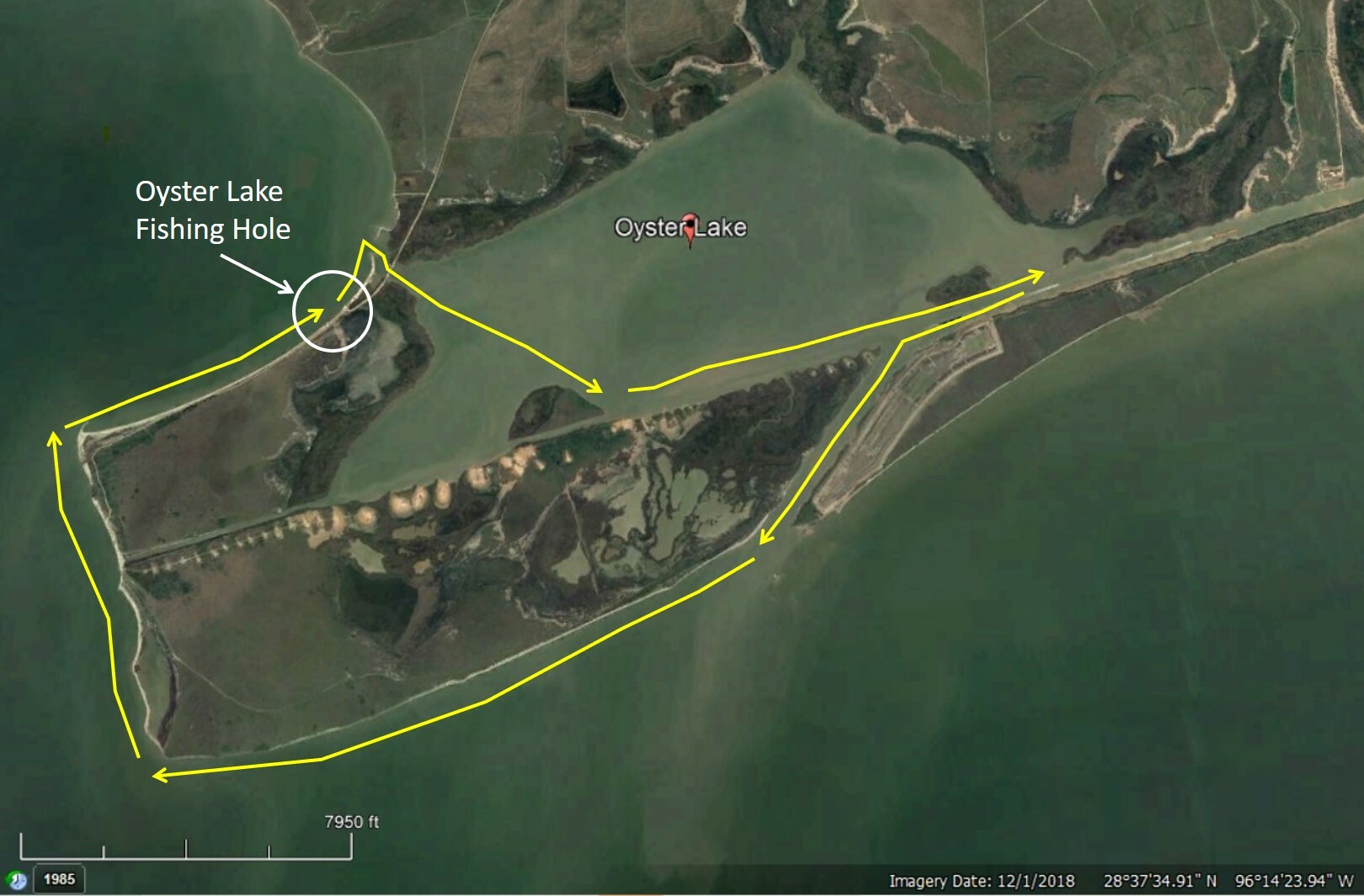
The described route starts at Oyster Lake Fishing Hole (in Google Maps. Satellite photo location 28 deg 36' 40.63" N, 96 deg 12' 54.50" W), which is in Oyster Lake Park. More general coordinates: 28.61255, -96.21402. Oyster Lake Fishing Hole is a shell beach just outside Oyster Lake. Paddle through a channel into Oyster Lake, east to ICWW, south west down ICWW to Matagorda Bay then WSW to Palacios Point and NW back to launch. See image below
Conditions will probably be ACA L1 to L2. Hazards are the usual: heat, sun, bugs, oyster reefs and boat traffic (big ones in the ICWW). Bring plenty of water (something with electrolytes - sugars and salts - wouldn't hurt), sun protection (sun cream, sun glasses, proper covering clothing, hat), bug repellant, snacks and lunch. Currents can be swift in channels especially on a falling tide.
|
Trip Leader
|
Phil Salvador
|
|
Trip Assistants
|
None so far
|
|
Trip rating*
|
1 - 2 with potential to be a level 3 trip depending on conditions
|
|
Ready to Launch at
|
9:00 a.m.
|
|
Duration (hours)
|
7, with lunch and other breaks
|
|
Paddling Miles (statute)
|
11 -12
|
|
Emergency Initiator (Level 3 & 4)
|
Not planned at this time. Will get one if plan to launch in Level 3 conditions
|
|
Emergency Phone #s
|
911
Galveston US Coast Guard409-766-5633
Corpus Christi US Coast GuardEmergency Phone:(361) 939-0450
Matagorda Sheriff(979) 245-5526
|
|
Latest Expected Return
|
4 PM
|
|
Auto Description/Lic #
|
Silver Honda CR-V TX JLX 7922
|
|
Distance from Houston
|
115 miles to SW
|
* Trip ratings are only a guide. Actual conditions will vary with wind and other weather.
Directions
Oyster Lake Park is located about 9 miles south of the town of Collegeport and approximately 15 miles south of the intersection of FM521 and FM1095. From Matagorda, take Hwy 60 north to FM 521. Take a left and head west to FM1095. Take a left and go south to County Road 365. Continue south on 365 until you cross the bridge. The road will dead end into the park. Coordinates: 28.61255, -96.21402
There are no amenities, but camping is allowed. The road to get there is passable by any vehicle but it is unpaved, rough and you will be travelling very slowly on the county road.
This is an ACA sanctioned event. Every participant must wear a PFD.
Waivers - Please complete our easy to use online waiver if you are a HASK member who has not signed a waiver within the last 12 months or a non- HASK participant. Read the waiver carefully. You give up substantial rights when you sign it.
- Add Smartwaiver with email address “noreply@smartwaiver.com” to your address book to ensure emails do not go to junk/spam.
- Select a link below to complete the online waiver.
ACA-HASK Adult Waiver ACA-HASK Minor Waiver
- Respond to the “Confirm your E-Signature” email from ACA / HASK to confirm your email address. Wavier is now complete and valid.
- You will receive a confirmation email. Please download and print a copy of the waiver and bring it to the trip put-in.
Guests – You are welcome to join us for a couple of paddle trips. HASK will cover the $5 ACA event membership for non-ACA members. Hopefully you will then join HASK and continue paddling with us.